The Not Safe Way to Tierradentro
- justinsterett9
- Jul 30, 2014
- 4 min read
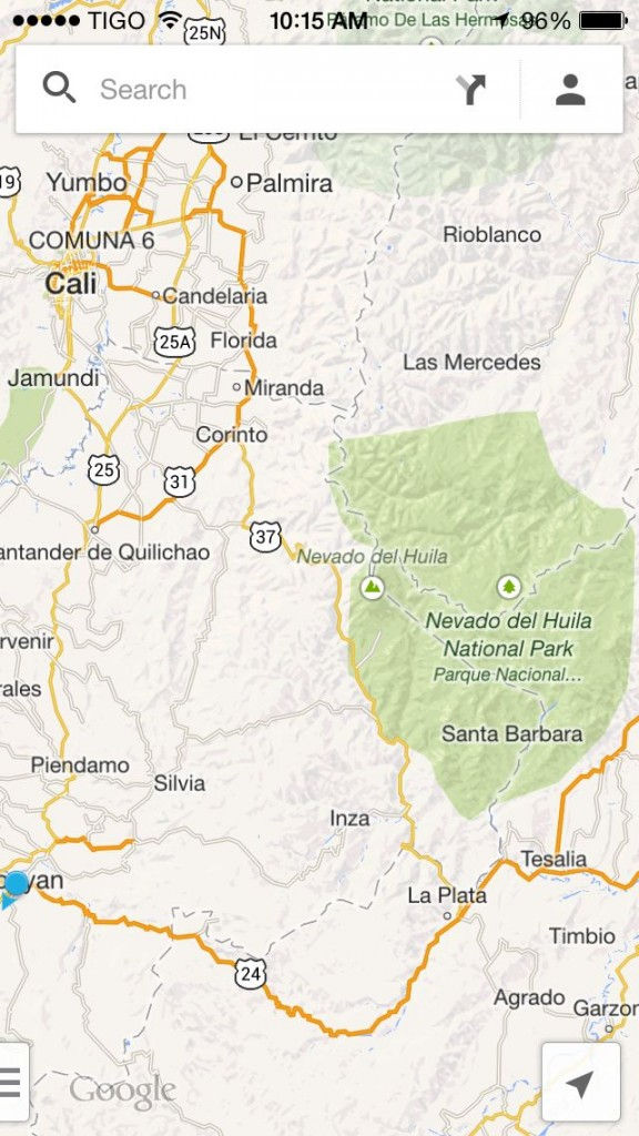
Just like Google translate I learned the lesson yesterday that Google maps can’t always be trusted. After a sweltering few days in Cali, we wanted to take a lesser traveled route to the national archaeologic site of Tierradentro which was supposed to have some interesting underground tombs and caverns remnant of a pre-Columbian era civilization. The route looked simple enough. According to Google it was major interstates the entire way. As we headed southeast out of Cali we stopped in a small town for some coffee. As expected the spectacle of two gringos on motos with ridiculous luggage strapped to the back drew some looks. I struck up a conversation with one man asking about the bike and he inquired where we were headed. I showed him on the map that we wanted to go to Tierradentro. The only one turn on the route was in a town called Corinto, which again Google maps highlighted as a major interstate. He commented to our surprise that this small town was pretty dangerous and we shouldn’t stop, and we certainly shouldn’t drive past the town due to numerous guerrilla activity. He emphasized pretty heavily to just make the left, don’t stop, and we will be fine. The first red flag had gone up.
As we drove the winding road to Corinto the red flags kept flying. I’ve seen a fair share of kitted out police while in Colombia, and for the majority it hasn’t been too shocking. When we were in Salento there was a small group of about four cops/soldiers in full fatigues with M4s walking the streets. They were generally in good spirits, I even remember they were flirting with a group of girls that walked by. The scene on the road to Corinto was not as chipper. We drove by legit two man elements in full body armor patrolling the highway. They looked no different than what you would see from a group of marines patrolling the streets in the Helmand province of Afghanistan, helmets, rifles, and all.
From the way the man outside Cali built it up I was expecting Corinto to be a war zone. As we entered the town it looked no different from any of the other small towns we had passed through on the way. The stores were open, people were selling arepas on the corner, and kids were riding their bikes in the streets. We made the left turn as Google commanded and followed the road as it led through a smaller street into a more back part of town, and then suddenly the road ended at a basketball court. Beyond the basketball court was the foot of the fairly vast mountain range we were expecting to drive through. I thought surely the map must just be off, I asked directions, asked again, then again, each time people looked confused as to what I was searching for. Highway 37 I would say showing them the very obvious yellow line on the map as I pointed towards the mountains. On the fourth attempt at asking directions in the town we were instructed not to stop in a lady told us that the way is not possible and there was no road, and that the mountain were labelled as one of Colombia’s infamous red zones where fighting between the military and guerrillas is still very active. As we thanked her and voiced our understanding we told her we would just turn back, she was not happy with this and instructed her husband that he needed to take us to the “police station” so that we would have safe passage out of town. As her husband got on his scooter to lead us to the police station I asked him if Corinto was actually that dangerous as I was becoming skeptical. Reluctantly he said that it was. It helps to understand that up until this point on the trip Colombians have made a point to advertise with a very real and strong sense of pride that their country is now finally safe to travel after decades of fighting. So the point was really driven home when this man from this small town said so confidently, yet shamefully that this place was indeed dangerous.
The “police station” that he drove us to was in the abandoned town square. The police/military/militia had created a sandbag fortress at one corner of the square. A solider in full battle rattle came out to greet the gringos in T-shirts. He explained what we had already suspected that Google maps was basically trying to kill us, and there was no such thing as highway 37, and the mountains were extremely dangerous. Echoing what the man outside Cali told us, he also iterated that going straight through this town and continuing on was dangerous as well. He suggested a route out of town leading us away from the mountains. As the conversation continued more soldiers came out of the barricade and it was clear that the rank structure was also increasing. Finally we were introduced to a Major who was clearly in command. He agreed with the other solider that we should leave on the prescribed route towards Popayan. There was some more commotion and the Major pulled a card out of his pocket and started dialing a number on the card, he said he wanted us to talk to this man. The card was for the Red Cross liaison in Cali.
As I spoke with the Spanish speaking man at the Red Cross surrounded by armed nervous looking soldiers in a town we shouldn’t be in it was clear at that moment that yes, indeed there are still some parts of Colombia that should be avoided. The red cross officer wanted to send a driver to escort us out of the city. I spoke with the Major again and he seemed to think this was a dumb idea. He got on the phone, there was some rapid dialogue and then he hung up. He said we would be safe to drive out of town. I’m still not 100% clear on why he thought we should talk to the Red Cross if he already knew there was a safe route for us to leave on. We left town without any issues with the mountains to our back racing through the flat farm lands on the very uneventful road to Popayan. Tierradentro never happened, but at least I’m not in a bamboo cage trying to raise money for my ransom.

(zona roja in the background)


Comments